
Security integrators: run a two week, edge first PoC to prove LiDAR security detection on site, measure latency and false alarms, and set acceptance KPIs.

Two Week PoC: When LiDAR Security Detection Works for Integrators

LiDAR security detection is one of the most reliable methods available for perimeter and intrusion detection, delivering precise, privacy-friendly 3D data that most camera-only systems cannot match. It works in total darkness, resists weather-driven false alarms better than infrared beams, and, when processed on the edge, avoids storing any personally identifiable data. Standards like ONVIF and RTSP make it straightforward to feed alerts into an existing VMS or PSIM, and some companies already run scoped proof-of-concept deployments to validate it before rollout.
TL;DR:
- Detection range, update rate, and end-to-end latency vary significantly across LiDAR sensors and should be validated under real-world conditions.
- Proper PoC testing requires site mapping, clear acceptance metrics, zone-specific tuning, and validation of detection accuracy, false alarms, and system uptime.
- Environmental factors like rain, fog, and vegetation swaying can cause false alarms, but adaptive filtering and overlapping sensors help mitigate these issues.
- The primary role of LiDAR is ideal in low false-alarm environments and strict privacy settings, with additional benefits from integration with video and ground sensors.
- Edge processing reduces latency and bandwidth demands, making real-time alerts more reliable and suitable for large site deployments.
Table of Contents
- How Does Lidar Detect and Classify Intrusions?
- What Are the Different Types of Lidar Sensors for Security?
- Where Does Lidar Fit in a Perimeter Security Architecture?
- How Does Edge Processing Change Lidar Integration?
- What Should a Lidar Security PoC Test Before Purchase?
- Why Do Environmental Conditions Cause False Alarms?
- What Does a Successful Lidar PoC Look Like in Practice?
- When Should Lidar Be Your Primary Detection Layer?
- How Beyondsensor Supports Your Lidar Deployment
- Sources
- FAQ
How Does Lidar Detect and Classify Intrusions?
A LiDAR sensor fires pulsed laser beams across its field of view and measures the time each pulse takes to bounce back. That return data builds a point cloud, a 3D map of every solid surface in range. Point density and angular resolution determine how much detail that cloud holds. A sparse 2D scanner might return a thin slice of the world; a high-resolution 3D unit can render enough geometry to distinguish a person's gait from a swaying tree branch at 80 meters.
From there, the detection pipeline runs three stages: segmentation, classification, and tracking. Segmentation isolates clusters of points that don't belong to the background scene. Classification decides what each cluster is, typically a person, vehicle, or animal, based on shape, height, and movement pattern. Tracking follows that object across frames so the system knows it's the same intruder, not three separate detections.
Two dominant approaches handle the tracking stage. Tracking-by-Detection (TBD) re-detects objects frame by frame and links them using motion and appearance cues. Newer neural approaches build persistent object memory, which helps when someone crouches, ducks behind a barrier, or briefly leaves the sensor's line of sight. Research on LiDAR-based person tracking shows that techniques like a discretized unscented Kalman filter, combined with feature similarity scoring, improve recall and tracking persistence specifically in occluded and cluttered scenes. Retaining low-confidence detections rather than discarding them outright helps recover a target that briefly vanishes, though it does require more careful filtering downstream to avoid resurrecting false positives.
When evaluating vendor claims, ask for hard numbers rather than marketing language:
- Detection range under real-world conditions, not the sensor's theoretical maximum.
- Update rate in Hz, which determines how quickly the system re-scans and reacts.
- End-to-end detection latency, from photon return to alarm trigger.
- Tested false-alarm rate, ideally broken down by intrusion class (human, vehicle, animal).
One underrated advantage rarely gets its due: privacy. Point clouds contain anonymous geometry, not facial features or pixel-level identity data, which sidesteps the PII concerns that dog camera-based systems in 3D detection pipelines built for person tracking.
What Are the Different Types of Lidar Sensors for Security?
Not every LiDAR unit suits every perimeter. Three broad categories dominate security deployments, and all trades range, resolution, and cost differently.
- 2D planar LiDAR scans a single horizontal plane, ideal for a tripwire-style detection line along a fence top. Range typically runs 30 to 60 meters, cost is lowest, and point density is thin, so classification accuracy suffers.
- Multi-layer 3D scanning LiDAR stacks multiple scan planes to build volumetric coverage, often reaching 100 to 200 meters with enough resolution to distinguish a crouching person from a dog. This is the workhorse for open perimeters and wide-area protection, at a higher price point and more demanding mounting requirements.
- Solid-state LiDAR uses no moving parts, which lowers maintenance and shrinks the housing, making it a fit for access points, gates, and compact installations where a spinning mechanical unit would be impractical.
Fence-mounted 2D units work well as a low-cost detection plane along a linear boundary. Tower-mounted 3D scanners suit open perimeters like airfields or substations, where you need wide coverage and depth to separate genuine threats from wildlife. Compact solid-state sensors fit naturally at doorways, loading docks, and vehicle gates, where space is tight and mechanical wear is a real maintenance concern.
The trade-off is consistent across all three: more range and resolution cost more and demand more careful mounting and calibration. A facility manager protecting a single server room entrance doesn't need the same sensor as a utility operator securing two kilometers of open fence line.
Where Does Lidar Fit in a Perimeter Security Architecture?
LiDAR earns its place in three recurring use cases, and how you deploy it shapes everything downstream.
- Virtual laser walls across fences. A string of 2D or 3D sensors creates an invisible detection plane along a fence line, triggering an alarm the instant something crosses it, regardless of lighting.
- Large-area perimeter detection. Tower-mounted 3D units cover open ground where fencing is impractical, such as airport buffer zones or solar farms, tracking intruders across wide, unobstructed terrain.
- Critical-asset protection. Compact sensors ring high-value targets like data center racks, generator yards, or equipment cages, catching close-range tampering that a distant camera would miss.
None of these work best in isolation. Layering LiDAR with video and existing fence or ground sensors closes blind spots that any single technology leaves open. A LiDAR sensor might detect motion through fog that defeats a camera, while the camera supplies visual context LiDAR can't. Ground-based vibration sensors catch a cut-fence attempt that a laser plane mounted higher up might miss entirely.
A typical alarm workflow runs like this: the LiDAR sensor detects and classifies an intrusion, the system triggers event replay using an RTSP stream or the recorded point-cloud segment. A human operator verifies the event visually, and, if confirmed, the system fires an automated response, lights, a gate lock, or a dispatch alert. That verification step matters. It's what separates a system operators trust from one they learn to ignore.
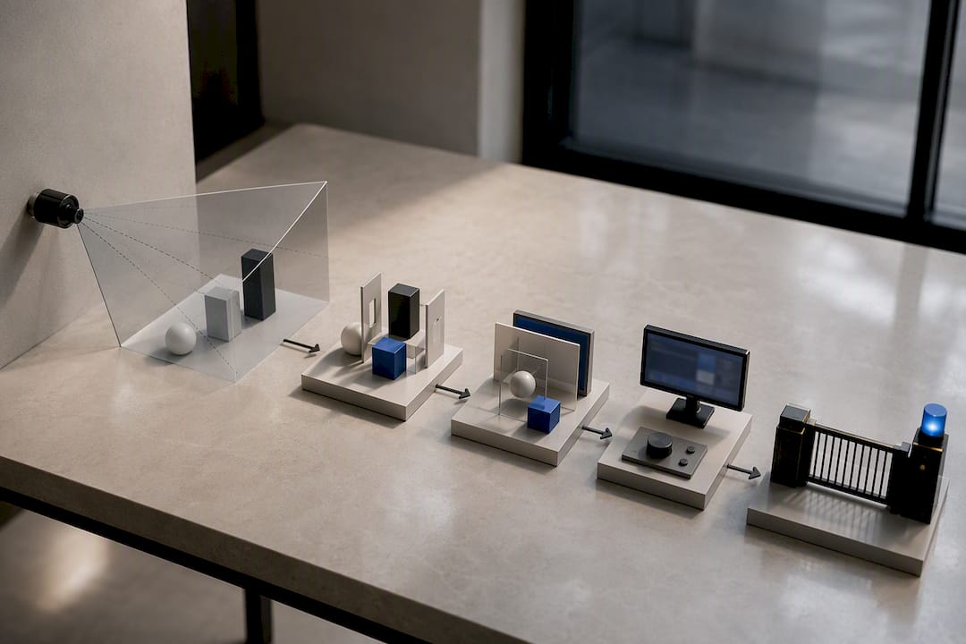
How Does Edge Processing Change Lidar Integration?
Running detection logic directly on the sensor, rather than streaming raw data to a central server, changes the economics of a LiDAR deployment. Edge-based Physical AI processing analyzes the point cloud where it's captured and sends only the resulting event, not gigabytes of raw scan data, back to the network. Recent industry collaboration between Intel and Outsight on spatial intelligence at the enterprise edge illustrates where this is heading: processing at the sensor cuts latency and bandwidth demand simultaneously, which matters most when you're running dozens of sensors across a large site.
Integration with existing security infrastructure follows a few consistent patterns:
- ONVIF and RTSP handle video verification streams so operators can visually confirm an alarm inside their existing VMS.
- MQTT, TCP, or HTTP carry lightweight event payloads, coordinate, timestamp, classification, into a PSIM or alarm management platform.
- PSIM/VMS event mapping ties LiDAR alarms into the same operator console used for cameras and access control, so security staff aren't juggling separate screens.
On the operational side, plan for redundancy on sensors covering critical zones, segment the sensor network from general IT traffic to reduce attack surface, and route confirmed alarms directly into SOC dashboards rather than a generic email queue nobody checks after hours. Beyondsensor's approach to edge-based analytics reflects this same philosophy: process locally, transmit only what matters.
Pro Tip: Ask any integrator proposing a LiDAR system how many milliseconds elapse between detection and alarm delivery to the SOC console, not just the sensor's raw scan rate. That end-to-end number is what actually determines response time.
What Should a Lidar Security PoC Test Before Purchase?
A proof-of-concept that only checks whether the sensor "sees" an intruder isn't a real test. A proper PoC validates the entire chain, from raw detection through to an operator's alarm screen, and it starts before the sensor ever powers on.
- Run a site survey first. Map line-of-sight obstructions, confirm mounting height and angle options, document the expected target profile (walking pace, running, vehicle speed), and flag vegetation or seasonal foliage that could shift over time.
- Set acceptance metrics in writing before testing begins. Detection rate against a known set of test walks, false-alarm rate broken out by class (human vs. animal vs. vegetation motion), classification accuracy, end-to-end latency, and system uptime over the test window all belong on that list. Vague terms like "reliable" or "accurate" don't hold a vendor accountable to anything.
- Map detection zones deliberately. Don't just draw one big polygon. Segment the coverage area into zones with different sensitivity thresholds, tighter near a gate, looser near a tree line prone to movement.
- Tune animal and vegetation filters on-site. Generic factory settings rarely match your specific terrain; expect at least one round of threshold adjustment after the first 48 hours of live data.
- Confirm a maintenance schedule before signing off. Optical lenses need periodic cleaning, and IMU recalibration keeps mounted units accurate after wind or vibration shifts their orientation over months.
Security integrators who skip the written acceptance criteria step are the ones who end up disputing results after installation, when it's expensive to fix.
Why Do Environmental Conditions Cause False Alarms?
Weather and vegetation remain the two most common culprits behind LiDAR nuisance alarms, and neither is a solved problem, though both are manageable with the right tuning.
Rain, fog, and airborne dust scatter laser pulses and can generate weak or noisy returns that a poorly tuned system might misread as a moving object. Adjusting detection thresholds and requiring multiple consecutive confirming returns before triggering an alarm cuts this down substantially. Moving vegetation, branches swaying in wind, tall grass, is the other repeat offender; classification filters that weigh object size, shape consistency, and velocity pattern separate a branch from a crouching person far better than motion detection alone. Occlusion is the deeper structural problem. A person who ducks behind a wall or vehicle temporarily disappears from a single sensor's view, and if the tracking algorithm doesn't retain that object's identity, the system may log it as a new detection or lose it entirely. Adaptive filtering methods that preserve low-confidence tracks through brief occlusion windows measurably improve tracking continuity in cluttered scenes, though overlapping sensor coverage at chokepoints and corners remains the more reliable structural fix.
- Multiple-return processing filters weak, scattered pulses caused by rain or dust.
- Shape and velocity filters separate vegetation motion from human or vehicle movement.
- Overlapping sensor fields of view preserve tracking through blind spots.
- Camera verification adds visual context for edge cases classification alone can't resolve.
No single sensor covers every angle of a complex site. When a perimeter includes tight corners, dense tree lines, or frequent maintenance vehicle traffic, pairing LiDAR with a verification camera or a second sensor covering the same zone from a different angle closes the gaps a lone unit will eventually miss.
What Does a Successful Lidar PoC Look Like in Practice?
Beyondsensor's two-week PoC for tailgating detection illustrates what a disciplined test cycle actually validates: detection accuracy at an access point, integration with an existing access control system (ACS), and event routing into a live SOC workflow, all measured against KPIs agreed before deployment rather than judged after the fact.
That kind of scoped validation matters more than sensor specifications alone. A well-run PoC checks event delivery reliability, RTSP verification quality, and whether operators can act on alarms without added friction, not just whether the sensor detects motion in a lab. A regional presence in Southeast Asia can support this kind of localized deployment work and ecosystem matchmaking between system integrators and facility owners who need site-specific validation rather than generic specifications.
For buyers building acceptance criteria, a workable checklist includes: detection rate above an agreed threshold across all test scenarios, false-alarm rate documented by class, confirmed ACS and SOC integration, and stable uptime across the full test window.
When Should Lidar Be Your Primary Detection Layer?
LiDAR earns the primary role when false-alarm tolerance is low and privacy requirements are strict, think data centers, utility substations, and government sites where every alert has an operational cost and camera footage raises compliance questions. It works better as a complementary layer when lighting is already good, budgets are tight, or the site has heavy vegetation that no amount of filtering fully tames.
Procurement teams get burned most often by skipping a scoped PoC and trusting spec sheets instead. Insist on real-world KPIs measured on your actual site, not a vendor's demo environment, and budget honestly for commissioning time and ongoing maintenance, not just hardware cost.
Total cost of ownership is driven less by the sensor price tag than by installation complexity, optical cleaning cycles, and how much threshold tuning your specific terrain demands. A flat fence line is cheap to maintain. A wooded perimeter with seasonal foliage change never really stops needing adjustment.
— Eumir
How Beyondsensor Supports Your Lidar Deployment
Some service providers give facility owners and system integrators a faster path to a working LiDAR deployment than building evaluation criteria from scratch. Instead of guessing at sensor specs from a data sheet, structured proof-of-concepts built around measurable KPIs can be applied to a site's actual layout, lighting, and threat profile.

A typical engagement starts with a site survey to map line-of-sight and mounting constraints, moves into a scoped two-week PoC with acceptance metrics defined upfront, and only proceeds to production rollout once those metrics are met on your own terrain, not a vendor showroom. Regional footprints in Southeast Asia mean that validation work happens with local context rather than generic assumptions imported from another market. For system integrators and facility teams ready to scope a deployment, the Beyondsensor system integrators page is the place to start that conversation.
Sources
- Intel and Outsight announce strategic collaboration to bring Physical AI–powered spatial intelligence to the enterprise edge
- SpbTrack / LiDAR-based person tracking research (arXiv preprint)
- Point-cloud-based 3D object detection and tracking for person detection (MDPI Sensors)
FAQ
Is LiDAR Better Than Infrared for Perimeter Detection?
LiDAR generally produces fewer weather-driven false alarms than infrared beams because it classifies object shape and movement rather than relying on a single interrupted beam, though both work well in darkness.
Does Lidar Security Detection Work in Rain or Fog?
Yes, but detection thresholds need tuning for reduced-visibility conditions, since scattered returns from rain, fog, or dust can otherwise trigger nuisance alarms.
Can Lidar Identify a Specific Person?
No. LiDAR captures anonymous 3D point-cloud geometry rather than facial or biometric detail, which is why it's considered privacy-preserving compared with camera-based identification systems.
How Long Does a Lidar Security PoC Typically Take?
Scoped proof-of-concept tests, like Beyondsensor's two-week tailgating detection deployment, typically run one to two weeks and validate detection accuracy alongside ACS and SOC integration.
What Integration Standards Should a Lidar System Support?
Look for ONVIF and RTSP support for video verification, plus MQTT, TCP, or HTTP event delivery for PSIM and VMS alarm mapping.
Recommended
Read More Articles
97% Takeover Success Demoed: Sensor Fusion Security for Practitioners
For security teams and system integrators: harden sensor fusion security with ETSI hardware controls, documented attack evidence, and a practical...

Stop False Dispatches: 5 SOP Steps for Singapore Alarm Triage
SOP first, verification led alarm triage workflow for Singapore facilities. Five SOP steps aligned to PDPC, SGPolice and ABS guidance.
Singapore Procurement: Live Pilot for Intrusion Detection Analytics
Procurement-first checklist for Singapore teams: require live pilots, add PDPA checks to RFPs, and judge intrusion detection analytics by pilot results...

Avoid Outages: IMDA/JST Camera Firmware Management for Administrators
Practical operations-first guidance for security administrators to run staged, auditable firmware updates across multi-site camera fleets, aligned to IMDA...
Let's Build YourSecurity Ecosystem.
Whether you're a System Integrator, Solution Provider, or an End-User looking for trusted advisory, our team is ready to help you navigate the BeyondSensor landscape.
Direct Advisory
Connect with our regional experts for tailored solutioning.