
Deploy crowd counting analytics that survive real deployments: practical edge processing, sensor fusion, and a pilot checklist for integrators.
Edge Fusion Makes Crowd Counting Analytics Work for Integrators
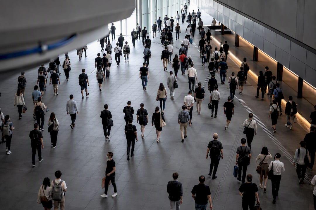
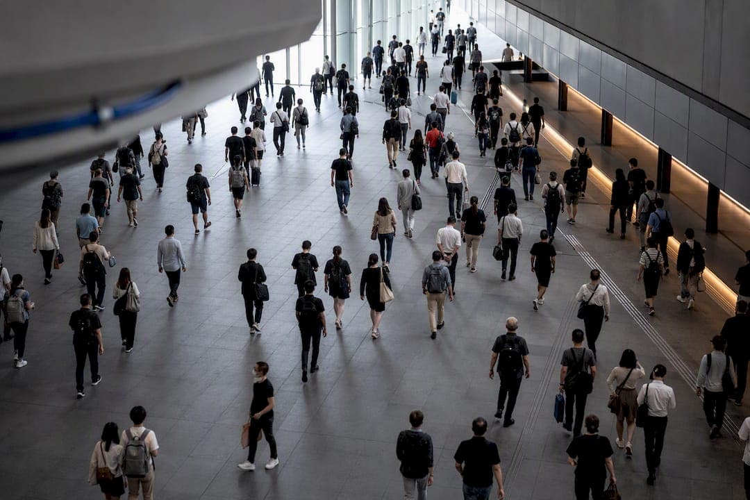
Crowd counting analytics estimate people or density from camera and sensor data, using deep learning to convert pixels into occupancy numbers. In production, the most reliable systems fuse lightweight edge AI with non-vision sensors like LiDAR or Time-of-Flight, trading a few points of raw accuracy for lower latency and stronger privacy guarantees. The dominant framing today is edge intelligence: push inference closer to the camera, keep raw footage off the network, and validate against your own venue before trusting any published benchmark.
TL;DR:
- Models should be selected based on expected maximum crowd density, with detection models suited for fewer than 50 people per frame and density maps for larger crowds.
- Benchmark datasets like ShanghaiTech and UCF_CC_50 offer limited real-world relevance, as accuracy often drops significantly under actual lighting and environmental conditions.
- Edge deployment is crucial for real-time alerts, reducing latency and bandwidth issues, but requires tiered processing and careful sensor placement to maintain accuracy.
- Proper camera positioning, height, angle, and field of view are essential for accurate density estimates, with overhead views providing the best baseline data.
- Combining vision with LiDAR or Time-of-Flight sensors enhances accuracy and privacy protection, especially in complex or low-light environments.
Table of Contents
- What Crowd Counting Analytics Actually Measure
- Detection, Density Maps, and Hybrid Models
- Why Lab Benchmarks Don't Match Field Results
- Getting From Prototype to Production
- What to Track and Where Deployments Break
- Matching the Method to the Mission
- Annotation Is the Hidden Cost Nobody Budgets For
- Real-Time Processing Doesn't Scale the Way You'd Expect
- Camera Placement Decides Accuracy Before the Model Even Runs
- Bias and Fairness Go Beyond the Privacy Conversation
- Comparing Commercial Crowd Counting Tools
- Making Crowd Data Talk to the Rest of Your Systems
- Where the Field Is Getting Ahead of Itself
- Building a Crowd Counting Pilot That Actually Holds Up
- Sources
What Crowd Counting Analytics Actually Measure
"Crowd counting," "people counting," and "crowd estimation" get used interchangeably, but they answer different operational questions. Crowd counting produces a total headcount for a scene, usually from a single frame or short window. People counting tracks individuals crossing a line or entering a zone over time, which is why retail and transit systems lean on it for footfall. Crowd estimation is the oldest and roughest of the three: coarse area-based approximations like the Jacobs method, which multiplies open-air footprint by an assumed density band, still gets used when sensor coverage is incomplete.
The KPI you need depends on the job:
- Footfall — entries and exits over time, the backbone of retail and venue capacity planning.
- Occupancy — live count inside a bounded space, critical for fire-code compliance and safety alerts.
- Density — people per square meter, which matters more than raw count at choke points.
- Flow — directional movement rate, used for queue and evacuation modeling.
- Dwell time — how long people linger in a zone, a signal urban planners and event operators both use differently.
Surveillance teams generally want density and occupancy. Urban planners care more about flow and dwell time across a corridor or plaza. Event organizers need all four stitched into one dashboard.
Detection, Density Maps, and Hybrid Models
Three model families cover almost every production system in the field today.
Detection-based models locate and box each person individually, then count the boxes. They work well in sparse to moderate crowds and give you bonus data (bounding boxes support re-identification and flow tracking), but accuracy collapses as occlusion increases. In a packed transit platform, half the crowd is hidden behind the other half, and detection models start missing heads systematically.
Density-map or regression models skip individual detection entirely. They learn to output a density heatmap where the sum of pixel values equals the estimated count, which is why they dominate dense-scene research. A critical review of deep learning crowd counting methods confirms these approaches handle occlusion and non-uniform distribution far better than detection pipelines, though they sacrifice per-person localization.
Hybrid and localization-aware models attempt to get both: density-level robustness with enough spatial awareness to support alerting by zone. Newer research on embodied, active-camera systems shows that letting a sensor reposition or combine viewpoints can further reduce the occlusion penalty that plagues fixed, passive cameras, as demonstrated in embodied crowd counting research.
- Detection: best under 50 people per frame, high compute cost per head.
- Density maps: best above a few hundred, lower per-inference cost, no individual tracking.
- Hybrid: higher engineering complexity, but the only realistic option when you need both zone-level density and safety-critical localization.
Pro Tip: *Don't pick a model family off a benchmark leaderboard. Pick it off your actual maximum expected density.
Why Lab Benchmarks Don't Match Field Results
Published accuracy figures almost always trace back to three datasets, and each has a specific personality that doesn't map cleanly onto your deployment.
- ShanghaiTech — split into sparser street scenes (Part B) and denser, more chaotic ones (Part A); still the most cited benchmark in the field.
- UCF_CC_50 — extremely dense, low-resolution images pushed to the extreme end of the count spectrum, useful for stress-testing density models but a poor proxy for typical venue footage.
- WorldExpo'10 — multi-camera, multi-scene data that tests generalization across viewpoints better than single-scene sets.
A systematic review of deep learning crowd density estimation found that 55% of studies published between 2020 and 2025 relied on deep learning architectures, with ShanghaiTech was the most frequently used benchmark dataset in many studies. That concentration means most published Mean Absolute Error (MAE) and Mean Squared Error (MSE) scores are effectively benchmarked against a narrow slice of camera angles and crowd behavior, not yours.
Practitioner analysis backs this up directly: controlled test conditions can produce accuracy figures north of 99%, but that number rarely survives contact with real lighting, weather, and camera placement, according to analysis of real-world model performance gaps. Treat any vendor's headline accuracy claim as a starting hypothesis, not a guarantee.
Getting From Prototype to Production
Moving a working model into a live deployment means solving problems the benchmarks never test: network limits, sensor blind spots, and privacy exposure.
Push inference to the edge whenever latency matters more than marginal accuracy gains. A systematic review of crowd density estimation explicitly notes the field's shift toward lightweight, edge-deployable models to cut the round trip time that cloud inference adds. For a real-time occupancy alert, a 400 millisecond cloud delay can be the difference between a warning and a report.
Sensor fusion closes the gaps vision alone can't handle. LiDAR and depth sensors generate anonymous 3D occupancy data that holds up in low light and doesn't degrade under occlusion the way 2D camera feeds do, a pattern documented in LiDAR-based crowd analytics applications. Signal-based and Time-of-Flight layers add continuous zone coverage between doorway checkpoints, reducing the single-point failure risk of relying on one camera angle.
Build privacy in at the architecture level, not as an afterthought: process frames on-device, output heatmaps or counts instead of raw video, and discard source imagery immediately after inference.
Before any wider rollout, run a pilot that mirrors reality:
- Select scenes that match your actual peak-density conditions, not idealized empty-room footage.
- Mount and angle sensors exactly as they'll sit in the final deployment.
- Calibrate against a manual headcount baseline across at least one full peak cycle.
- Log environmental variance, lighting, weather, crowd behavior, before trusting the numbers.
Pro Tip: Run your pilot at the exact time of day your crowd peaks, not during a quiet mid-morning test window. A system validated on Tuesday at 11 a.m. tells you almost nothing about Saturday night at capacity.
What to Track and Where Deployments Break
A crowd counting system needs its own monitoring layer, separate from whatever dashboard displays the counts.
Track MAE and RMSE against a periodic manual baseline, detection precision and recall if you're running a detection-based model, end-to-end latency from frame capture to alert, uptime, and drift indicators that flag when live accuracy starts sliding away from your pilot baseline.
- Occlusion — dense crowds hide bodies behind bodies; density models handle this better than detection models but aren't immune.
- Perspective distortion — wide-angle lenses shrink distant heads, which skews density maps unless the model was trained on similar geometry.
- Lighting shifts — dawn, dusk, and artificial lighting changes can silently degrade accuracy between otherwise identical scenes.
- Camera vibration — outdoor mounts on poles or structures introduce motion blur that most benchmark datasets never simulate.
- Crowd dynamics — sudden surges or directional shifts stress models trained on static or slow-moving reference data.
Set a retraining trigger, not just an alert threshold. If drift indicators cross a set band for a defined window, that's your signal to recollect baseline data rather than wait for a visible failure. Redundant sensor coverage at chokepoints reduces the odds that one failure mode takes down your entire monitoring picture.
Matching the Method to the Mission
Public safety, urban planning, events, and transit each pull different levers from the same underlying technology.
- Public safety deployments need density-per-square-meter thresholds tied to choke-point geometry, not raw headcounts, so alerts fire before a corridor becomes dangerous rather than after.
- Urban planning projects lean on flow and dwell-time data across pedestrian corridors and plazas, often aggregated over weeks to inform infrastructure decisions rather than real-time response.
- Event and venue operations need live occupancy alerts for capacity control during the event, plus footfall and dwell data afterward for post-event analytics and next year's planning.
- Transit and station management focuses on queueing and throughput, since platform overcrowding and gate bottlenecks are the two failure points that cause the most operational disruption.
Retail and airport deployments show the pattern clearly: footfall data only becomes valuable once it's tied to conversion, staffing, or scheduling systems, a link well documented in people counting and conversion research. Counting people is the easy part. Connecting that count to a decision is where most projects actually earn their budget back.
Annotation Is the Hidden Cost Nobody Budgets For
Every density-map model starts with dot-annotated training images, where a human marks the center of every visible head in a frame. In a UCF_CC_50-style image with several thousand people, that's not a quick task. It's hours of careful, error-prone manual labeling per image, and the annotators themselves disagree on ambiguous cases: partially occluded heads, distant blurs, and figures at the frame's edge.
That disagreement matters more than it sounds. Dense scenes make this worse because annotation error compounds with the same occlusion problems the model itself struggles with, so the noisiest labels tend to land on exactly the hardest cases.
Local data makes the problem more acute, not less. A model trained on ShanghaiTech's overhead street angles annotated by one labeling team will carry that team's specific conventions into a domain (say, a stadium concourse) where the camera geometry, lighting, and crowd density behave nothing like the source dataset. Teams building proprietary training sets for a specific venue need annotation guidelines that are explicit about edge cases: how to count a person half out of frame, how to handle a densely packed cluster where individual heads blur together, and whether to count children differently than adults for density purposes.
Semi-automated annotation, where a preliminary model proposes head locations for human correction, speeds up labeling considerably but introduces its own bias: annotators tend to trust the model's suggestions even when they're wrong, quietly baking the old model's mistakes into the new training set. Periodic blind re-annotation of a sample batch is the most reliable check against that drift.
Real-Time Processing Doesn't Scale the Way You'd Expect
A single camera feed running a density-map model on a capable edge device is a solved problem today. The scaling issue shows up when you go from one camera to fifty, or from one venue to a citywide network, because the bottleneck rarely stays computational. It becomes a bandwidth and orchestration problem.
Centralizing inference in the cloud for a large camera network means every feed streams continuously, which multiplies bandwidth costs and adds the latency penalty that edge intelligence was specifically designed to avoid. Distributing inference to the edge on each camera or a local gateway solves latency and bandwidth at once, but it introduces a fleet-management problem: dozens or hundreds of edge devices each need model updates, health monitoring, and calibration checks, and a device that silently drifts out of calibration in a low-visibility subway tunnel can go unnoticed for weeks without proper telemetry.
Real-time alerting adds another layer of scaling pressure. A system generating density readings every second across fifty zones needs a rules engine that can evaluate calibrated thresholds, people per square meter relative to each choke point's specific geometry, without flooding operators with redundant or low-value alerts. Naive systems that alert on raw count spikes tend to generate so much noise that operators start ignoring them within days, which defeats the purpose of real-time monitoring entirely.
The practical fix is tiered processing: lightweight models run continuously at the edge for baseline monitoring, while heavier models activate only when a preliminary threshold is crossed, reserving the more expensive computation for the moments that actually warrant it. That approach keeps a large-scale deployment responsive without requiring every camera to run its most demanding model around the clock.
Camera Placement Decides Accuracy Before the Model Even Runs
No amount of model tuning fixes a badly placed camera. Height, angle, and field of view set the ceiling on what any downstream algorithm can extract from a scene, and this is one of the most underestimated variables in the entire pipeline.
Overhead or steep downward angles minimize occlusion, since heads and shoulders stay visible even in dense clusters, which is exactly why most benchmark datasets favor that geometry. A low, oblique angle, the kind you get from a wall-mounted camera in a corridor, causes people in the foreground to block people behind them, and density models trained on overhead data often perform noticeably worse when deployed at a shallow angle they never saw during training.
Field of view creates its own trade-off. A wide-angle lens covers more physical area per camera, reducing hardware costs, but it compresses distant subjects into fewer pixels and distorts scale across the frame, both of which hurt density accuracy at the edges of the shot. A narrower field of view improves per-person resolution but requires more cameras to cover the same physical space, which raises both hardware and integration costs.
Mounting height matters too, in ways that are easy to overlook during planning. A camera at 3 meters and one at 8 meters produce very different perspective distortion for the same scene, and a model calibrated on one won't transfer cleanly to the other without retraining or at least fine-tuning on locally collected footage. Vibration from wind, foot traffic on a shared structure, or HVAC systems introduces motion blur that most training datasets, captured under controlled conditions, never account for.
The practical rule: match your camera geometry to your model's training data as closely as possible, or budget for local fine-tuning. Treat placement as a design decision made before model selection, not an afterthought bolted on during installation.
Bias and Fairness Go Beyond the Privacy Conversation
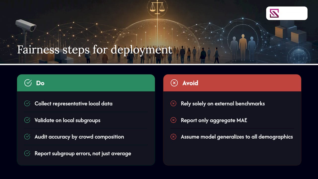
Privacy dominates most ethical discussions around crowd analytics, and rightly so, but it's not the only fairness question worth asking. Training data bias creates real accuracy disparities that most deployment teams never test for.
Most public benchmark datasets were collected in specific geographic and cultural contexts, often urban Chinese street scenes in the case of ShanghaiTech, or specific event types in others. A model trained predominantly on those scenes can underperform when deployed in a venue with different clothing patterns, different typical group sizes, or different lighting conditions tied to local architecture. That's not a hypothetical: crowd composition, formal event attire versus casual street clothing, religious head coverings, children mixed into adult crowds at different ratios, all shift the visual signal a model relies on, and a model never exposed to that variation during training will simply count some populations less accurately than others.
That creates a genuine fairness problem when the output feeds into decisions with real consequences. If an occupancy alert system underestimates density in a specific type of crowd because the training data underrepresented it, the safety margin that alert is supposed to guarantee shrinks precisely for the population the system handles worst. The same logic applies to urban planning decisions built on flow data. A pedestrian count that systematically undercounts a particular demographic skews the infrastructure investment that data eventually justifies.
The fix isn't complicated in principle, even if it's expensive in practice: collect and validate against representative local data rather than trusting a benchmark trained somewhere else, and audit accuracy across different crowd compositions rather than reporting a single aggregate error figure. A model with excellent average MAE can still be quietly failing a specific subgroup, and average error is exactly the metric that hides that failure.
Comparing Commercial Crowd Counting Tools
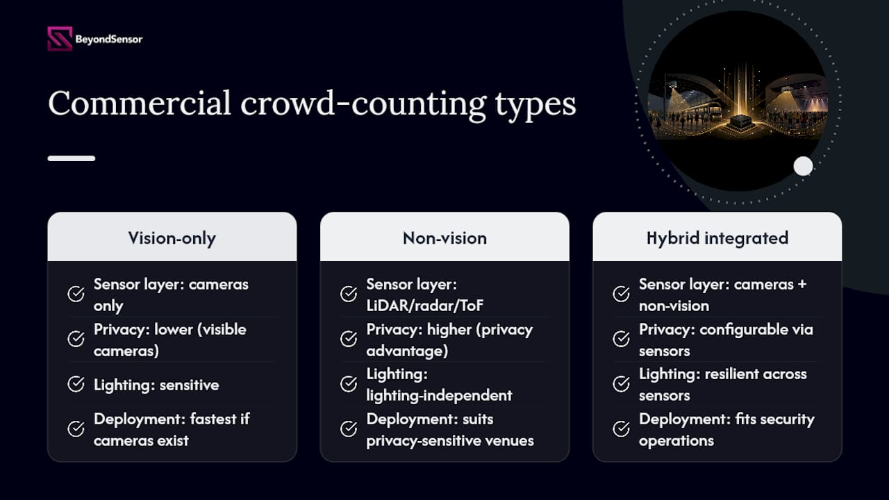
Commercial crowd counting analytics tools generally fall into three categories, and the right one depends less on brand and more on what sensor layer and deployment model fits your constraints.
Vision-only platforms rely entirely on existing or new camera infrastructure and run detection or density-map models against that footage. They're the fastest to deploy if cameras already exist, but they inherit every limitation of camera-based sensing: occlusion, lighting sensitivity, and the placement issues covered above.
Non-vision sensor platforms use LiDAR, radar, or Time-of-Flight sensors instead of or alongside cameras, trading some spatial resolution for privacy advantages and lighting independence. These tend to suit venues where visible cameras raise privacy concerns or where lighting conditions vary too much for consistent vision-based accuracy.
Hybrid integrated platforms combine both sensor types with a unified dashboard, alerting engine, and often integration hooks into existing security or building management systems. This category tends to fit organizations that already run broader security operations and need crowd data feeding into the same operational picture as access control, video management, and incident response.
Evaluation criteria worth weighing across any commercial option: does the vendor publish field validation data or only lab benchmarks, does the platform support edge deployment or require continuous cloud connectivity, what's the actual data retention and privacy posture for any video captured, and how well does the alerting engine support calibrated, geometry-aware thresholds rather than raw count triggers. A platform that scores well on published accuracy but fails any of those four questions is a harder sell for a serious deployment than a mid-tier accuracy platform that gets deployment fundamentals right.
Making Crowd Data Talk to the Rest of Your Systems
Crowd counting analytics deliver the least value when they run in isolation. The real payoff comes from feeding density, flow, and occupancy data into the broader systems already managing a facility or a city.
Access control integration lets an occupancy reading trigger a real response, locking a door, capping entry, or rerouting flow, rather than just displaying a number on a dashboard nobody's watching in real time. Video management system integration means an occupancy alert can automatically pull the relevant camera feed for an operator, cutting the seconds it takes to manually locate the right view during an actual incident.
At the smart city level, crowd data becomes one input among several: traffic signal timing, public transit dispatch, and emergency response routing can all factor in real-time crowd density from public plazas, transit stations, and event venues. That only works if the crowd analytics platform exposes data through APIs that other municipal or building systems can actually consume, which is where a lot of otherwise capable point solutions fall short. A model with excellent accuracy but no clean API integration ends up as a standalone dashboard nobody outside the security team ever looks at.
The practical guidance for technical teams: evaluate integration capability with the same rigor you apply to model accuracy. A slightly less accurate system that plugs cleanly into your existing surveillance analytics infrastructure and alerting workflow will often deliver more operational value than a marginally more accurate system that requires custom integration work for every downstream connection.
Where the Field Is Getting Ahead of Itself
The conventional pitch on crowd counting analytics oversells accuracy and undersells the engineering work around it. Vendors lead with benchmark numbers, and technical buyers, reasonably, want a single figure to compare options. But a 2% MAE improvement on ShanghaiTech tells you almost nothing about how a system performs at your specific choke point, with your specific lighting, at your specific peak density. The systematic review data on edge intelligence adoption and the practitioner analysis on the gap between lab and field results point to the same conclusion from different angles: the industry knows benchmark accuracy is a weak proxy for field performance, and it's still the number everyone leads with.
What the research actually supports is a shift in priority. Sensor fusion and representative local validation matter more than squeezing another fraction of a point out of a density-map architecture. A hybrid system with modest published accuracy but solid LiDAR backup at your actual chokepoints will outperform a headline-accuracy vision-only model that falls apart the first time your lighting changes or your crowd wears winter coats.
If you're prioritizing one thing first, prioritize the pilot. Not the vendor demo, your pilot, at your venue, at your peak density, with your camera geometry. Everything else, model family, dataset choice, edge versus cloud, gets easier to decide once you have that ground truth in hand.
— Eumir
Building a Crowd Counting Pilot That Actually Holds Up
Beyondsensor works with system integrators and facility teams who need crowd density data that survives contact with a real deployment, not just a benchmark leaderboard. Where a vision-only pilot can stall out on lighting changes or occlusion at your busiest chokepoint, a fused approach, pairing lightweight edge inference with LiDAR or Time-of-Flight sensing, keeps accuracy stable when conditions don't cooperate.

That combination also cuts the two costs that sink most crowd analytics projects: constant cloud bandwidth and the privacy exposure of storing raw video. Beyondsensor's sensing technology suits industrial and public-safety security teams who need occupancy alerts tied to actual choke-point geometry rather than raw counts, plus integration paths into existing access control and monitoring systems. Construction and site-safety teams have seen similar edge-analytics gains applied to real-time safety monitoring on active job sites.
If your team is scoping a pilot, start with Beyondsensor's system integrator resources to map sensor mix and deployment architecture to your specific venue before committing to a single vendor's benchmark numbers.
Sources
- A Systematic Review on Crowd Density Estimation Using Deep Learning Techniques: State-of-the-Art Methods and Future Challenges
- Crowd counting analysis using deep learning: a critical review (Procedia Computer Science, 2023)
- Embodied Crowd Counting (arXiv)
Recommended
Read More Articles
RTSP Security Risks: Integrators Must Block Exposed Ports 554 and 8554
See how integrators can reduce RTSP security risks: close exposed ports 554 and 8554, secure camera access, and verify each deployment with practical checks.
Require MAEpp and X Accuracy Before You Buy People Counting Systems
Verify people counting accuracy by demanding MAEpp, X Accuracy, and directional-bias reports. Validate on-site with at least 100 events per direction...
30–90 Day Pilot Validates Redundant Camera Networks for Engineers
Standards led, practical steps for engineers to deploy redundant camera networks: MRP, dual homing, and aggregation patterns, commissioning checks, and...
30 Day Pilot Proves Video Analytics Accuracy for Security Teams
Validate video analytics accuracy with scenario tests, camera tuning, transfer learning and a 30 day edge first pilot for security teams.
Let's Build YourSecurity Ecosystem.
Whether you're a System Integrator, Solution Provider, or an End-User looking for trusted advisory, our team is ready to help you navigate the BeyondSensor landscape.
Direct Advisory
Connect with our regional experts for tailored solutioning.